
|
Seminar Description | Software requirements | |
| Thursday, April 29, 2010 9:00 a.m., 11:00 a.m., & 3:00 p.m. Pacific Time (US & Canada) 12:00 p.m., 2:00 p.m., & 6:00 p.m. Eastern Time (US & Canada) 4:00 p.m., 6:00 p.m., & 10:00 p.m. UTC/GMT |
Thursday, April 29, 2010
Using ArcMap in ArcGIS Desktop 10 - Seminar


Thursday, April 22, 2010
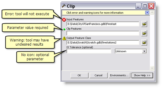
SQL Statement for Selecting Characters, sequential meaning coded value
So I received a spreadsheet where the number of asterisks meant the rating of a particular record. It wasn't hard to figure out this SQL statement but I thought it would be valuable to post as remembering something like this may come in handy one day. So I'll include an example using asterisks but this could be used for any type of situation where you need to include a single character but omit when that character comes up twice in sequence.
"Field_Name" LIKE '%*%' AND "Field_Name' NOT LIKE '%**%'
* = the ASCII character we are looking at
Selecting Features by a character without selecting the sequential iterations of it. Maybe a good application would be for like selecting singe 'L's in Spanish language databases w/out selecting the doube 'LL's.
Monday, April 5, 2010
ArcGIS 10 Resources Center

I'm really excited about the level of Python integration and support at the ArcGIS 10 level. I just feel as if Geoprocessing is taking a front seat and this new version of ArcGIS is going to bring GIS to the out of the early 2000's.
ArcPy is a site-package that builds on (and is a successor to) the successful arcgisscripting module. Its goal is to create the cornerstone for a useful and productive way to perform geographic data analysis, data conversion, data management, and map automation with Python.
This package provides a rich and native Python experience offering code completion (type a keyword and a dot to get a pop-up list of properties and methods supported by that keyword; select one to insert it) and reference documentation for each function, module, and class.
The additional power of using ArcPy within Python is the fact that Python is a general purpose programming language. It is interpreted and dynamically typed and is suited for interactive work and quick prototyping of one-off programs known as scripts while being powerful enough to write large applications in. ArcGIS applications written with ArcPy benefit from the development of additional modules in numerous niches of Python by GIS professionals and programmers from many different disciplines.
Subscribe to:
Posts (Atom)